
Walking in Scotland just got better with the unveiling of a new map detailing many miles of waymarked walking routes on the south side of iconic Loch Ness.The new Harveys map details the 28-mile South Loch Ness Trail and the 50-mile Trail of the Seven Lochs route.
More about the South Loch Ness Trail
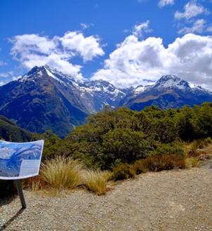
The South Loch Ness Trail is a continuous, managed track along the south side of the loch. Walkers and cyclists can revel in a fabulous landscape while travelling the waymarked route starting from Loch Tarff near Fort Augustus and heading to Torbreck on the outskirts of Inverness. Highlights of the South Loch Ness Trail include the spectacular falls at Foyers (made famous by Scottish bard Robert Burns), the site of an Iron Age fort at Inverfarigaig and the finest surviving example of a single span General Wade bridge dating from 18th century. The South Loch Ness Trail offers both high and low-level walking and cycling. At points, the trail is at the loch edge, while the route also rises to more than 1200ft. You will be able to feast your eyes on sections of the Great Glen and across the loch to impressive Urquhart Castle standing on the northern shore.
More about the Trail of the Seven Lochs
This walk and a cycle way is a 50-mile sustainable loop route offering stunning views and varied terrain for walkers and riders on the south side of Loch Ness. The Trail of the 7 Lochs is a circular route so there is no designated starting point. There is a nominal starting point at the Forestry Commission Centre at Inverfarigaig as there is good parking there and toilets. The route is split into a north and south loop or can be walked as a total long-distance way marked route.
Why you might need a walking map
 Although the route is way marked, the new Harveys map, produced in association with local tourism organisation Destination Loch Ness, is an essential item for exploring Loch Ness. The whole route appears on one map and there is also general information, useful telephone numbers and a full key. The polyethylene map is light to carry and compact as well as being durable and 100% waterproof. The map costs £5.95 and is available from good outdoor shops, Visitor Information Centres and direct from www.harveymaps.co.uk
Let us do the walk planning for you
If you are inspired to walk on the south of fabulous Loch Ness why not let MacsAdventure take the hassle out of the route planning and accommodation booking. This Loch Ness Trail is a popular walking holiday and offers some wonderful attractions including: * Dores pebble beach with stunning views along the length of the Loch Ness * The Falls of Foyers, which is one of the most spectacular waterfalls in the Highlands * Perhaps a glimpse of the Loch Ness Monster! Tell us where you'll be walking in Scotland this year?


 Australia
 New Zealand
 South Africa
 European Union