
 “There’s a route to be checked – the Levadas of Madeira, can you do it?” ... the phone call that started this adventure. Six days hiking around a European sub-tropical island! A quick scan of the route overview would have convinced any avid walker. Four days later the sight of Funchal’s extraordinary runway warmed the heart of an ex-naval aviator. clic any blue pic Sao Lourenco Peninsula & Return In 1418, two of Henry the Navigator’s sea captains were blown off course and rode out a storm in the shelter of an island they named Porto Santo, or “Holy Harbour”.
  Mysterious atlantic islands had been described before by early Roman and Florentine historians, yet the discovery of Madeira is officially credited to Captains João Gonçalves Zarco and Tristão Vaz Teixeira who settled first on Porto Santo, then the following year on Madeira itself. The ragged coast line of the Sao Lourenco Peninsula is where the Portuguese first stepped ashore. Today’s visitor can experience the dry, semi-arid environment and spectacular geology in a fabulous half-day walk, enjoying stunning views little changed since the arrival of the early settlers. Now protected as a nature reserve, the peninsula’s wild life is shielded from the pressure of man. Avians abound. Shearwaters and yellow legged gulls crowd the cliffs; rock sparrows, canaries and pipets flit through the dry scrub; diminutive kestrels scour the steep valleys for small prey.

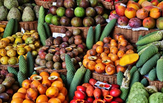
Offshore the bigger game is less easy to spot but dolphin and sea lion live in these waters, whilst “espada”, the black scabbard fish with jaws full of needle-like teeth, are better encountered in numerous Madeiran restaurants like the Gala Restaurant&Patisserie, Machico. Levada Canical to Porto da Cruz On leaving Machico, once the Island’s capital, the weather began clear and the slope steep then, having reached the ridge, a short diversion was taken to visit Pico Facho, the high point above the town. The extra climb was well worth the view and would have pleased everyone from plane spotter to botanist – for early December, the colour was brilliant.

However, the cloud over the mountains served notice of what was to follow. On arrival at the “casa dos levadeiros”, the water house at the entrance of the Canical Tunnel, the mist had veiled the high peaks and the rain had set in. However, walking alongside levadas means level paths and, despite the disturbance of the works in progress, the going was easy. The weather deteriorated as the views became more luxuriant and the proximity of the wild northern coastline made itself felt.

Passing through the ridge line at Boca do Risco, the pressure of the rain became relentless and the decision to turn back was inevitable. Porto da Cruz was cut off by road, houses were damaged and a return to Machico was the only option. The North Coast walk is a fantastic trek – but not today. Like any hike in the mountains, when the weather and terrain rule against free passage, the walker is obliged to pay due homage and retire. Paul da Serra - Levada do Norte - Encumeada Frantic phone calls by the local agent rearranged the itinerary for the following day. Although the weather continued to be foul in the North East, our tour recommenced from the Island’s high central plateau.

Looking down at Sao Vicente on the North Coast, it was hard to believe that Porto da Cruz, only thirteen miles distant, was still struggling to clear roads and restart services. Paul da Serra is the largest expanse of flat ground on the Island and stands at an elevation of 1500 metres above sea level. The importance of the area is significant, not just for its tourism, but also because the level gradient of the terrain encourages the abundant rainfall to filter through the soil and recharge ground water stocks while reducing run off. In addition, the exposed plateau offers an excellent location for wind turbines and the installation here accounts for virtually all the wind generated electricity in Madeira. Pushing downhill through the gorse demanded a little care – even in the dry, it was worth pulling on the waterproof leggings for protection.
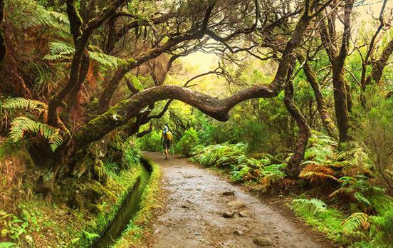
On a clear day, the vistas are breathtaking but descending down the water course of the ravine required concentration: watching the footing, following the twisting path, looking out for arrows and red/white trail markers. The Levada do Serra provides welcome relief from the prickly scrub but it is short and soon peters out into a rough path. Glimpses of light and greenery are snatched between gaps in the prolific foliage, revealing the valley of Ribeira de Sao Vicente below. As thirst and hunger turned our minds to a drink of water and a dry biscuit, Madeiran hospitality came to our aid. A gathering of families and friends pressed us with delicious, moist, orange cake and Poncha, Madeira’s traditional tipple of white cane rum, lemon and honey.  If Paraffin is looking glazed, that’s his second shot and he’s really worried about his map reading! The Levada do Norte appears a little like an English country canal at first, but the walker is led into a world of water and sub-tropical forest – levada walking at its best. Totalling approximately fifty kilometres and stretching as far as the South Coast, this levada is the longest and one of the most beautiful. Construction began in 1947 and within five years water flowed along its entire length. The numerous tunnels can be cramped from both above and the side, slippery underfoot and very dark – often simultaneously. A good head torch is essential, preferably trekking poles too. The beauty of this world is spell binding and all too quickly the end of the last tunnel looms large.

Within minutes the Residencial Encumeada is visible beneath, serene amongst the clouds, awash with greenery and foliage. 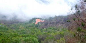
The rain did catch up towards the end of the day, just light drizzle on a hot forehead.
After a great day hiking....what now?More Poncha, of course! Encumeada - Faja Escoura in the Curral das Feiras The Residencial Encumeada has the feel of an Alpine ski lodge, somewhat spartan with its terracotta floor tiles, but offering a wide welcome in a wonderful mountain setting – lovely to enjoy from your own balcony. 
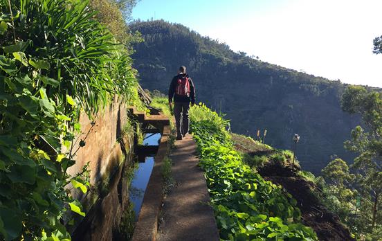
This hotel caters well for the walker, with a huge map of Madeira and hiking routes displayed in Reception. The buffet breakfast set up the day handsomely and it was a pleasure to depart the same way that we arrived – on foot. Tracing the contours at the feet of Pico Grande, the earthen path leads beneath a green steel pipe which ducts the waters of the Levada do Norte to the hydro-electric power station at Serra de Agua and on to the reservoir above Camara de Lobos. This is the Socorridos multi-purpose system for public water supply, irrigation and electrical generation. An improvement will be the installation of a reversible cycle, utilising off-peak thermal and wind generated power to elevate the water stocks for reuse during periods of peak public demand. Madeira generates over twenty percent of its electrical needs using renewable resources, of this water is king and the future of the levada system is secure. The smell of eucalyptus permeates the air as a series of rustic but sturdy bridges are traversed en route to the old settlement of Grass Bridge. You will recognise it when you get there. The old buildings, ancient terraces and autumnal colours create a mellow mood and it is a joy to sit and savour the silence for a while. Despite the late season, this is Madeira and the flowers are irrepressible. From Grass Bridge the slope becomes stern and will require effort for the next hour. The path is paved and even but inclined to be greasy in the wet. Plant your boots on the cement between the crazy paving for better grip, dig in with the trekking poles, be aware that the profusion of plant life can mask the sheer slope close to your feet.

Climbing into the clouds always feels surreal and adding a Madeiran skyline creates the illusion of an epic Chinese fantasy film. Great place for a picnic. At the ridge line of Boca do Cerro, the sounds of the town of Curral das Feiras filter through the mist but it remains hidden. The downward path steepens sharply, zig-zagging as the clouds close in. Natural bridges are protected by firm handholds but the feet are inclined to skid away from under the walker. Finally the scrub gives way to eucalyptus and sweet chestnut, the hairpin bends soften and the valley of Curral das Freiras emerges from behind a cloudy veil.

The village of Faja dos Cardos at the head of the Nuns’ Valley. Until the construction of the tunnel connecting the town of Curral das Freiras with Funchal in the 1950’s, the communities of this valley were very isolated. Footpaths such as this acted as vital links to the outside world and the postman used them daily. It is sobering to imagine such an arduous life style and even more so to discover that the postman at the time... was a woman.

The ridge from Pico Grande to Pico Cerco and beyond looked good looking back, but perhaps not quite as good as the cosy cafe in the centre of the small village of Faja Escoura, our pickup point.
Pico das Pedras - Caldeirao Verde - Ihla Our rearranged itinerary returned to the weather disrupted North East today. With the expertise of long practice, the roads to Porto Da Cruz had been cleared, although a sad thought was spared for the unfortunate homeowners who would spend the next months and years rebuilding.

Jaunty houses and flower bordered levadas welcomed us to one of the most popular walks on the Island. An easy, well marked trail leads the walker to the Parque das Queidamas where you find yourself entering a UNESCO World Heritage site. “Madeira” translates from Portuguese to English as “wood” and the National Park is home to the largest surviving example of Laurisilva, laurel forest, that once covered much of Southern Europe 15-40 million years ago. It is a unique environment, shared only with the western group of the Canaries, the Azores and the Cape Verde Islands.

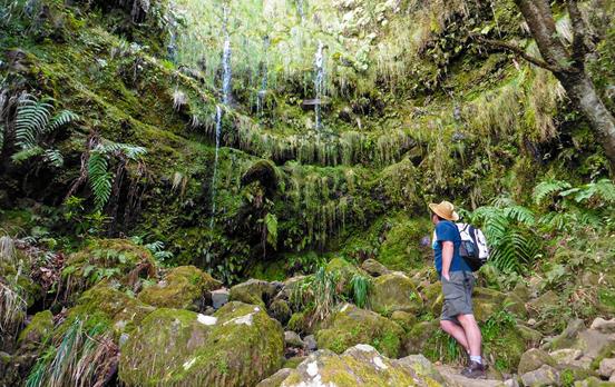
As the Park buildings are left behind the Levada do Caldeirao Verde reveals its true nature: beautiful, enchanting yet ever demanding respect. 
The building of this waterway commenced in 1796 and enjoyed none of the mechanical assistance on which today’s society depends. The methods were primitive; men lowered in wicker baskets tethered to trees, swinging picks and shovels. That forced labour was used must be certain but there were many who came of their own volition. The Herculean labour and courage of all of them must be saluted. Today’s path is well served with safety lines, installed by modern “levadeiros” with the same commitment as their forerunners. Following the 980 metre contour, the tunnels are as impressive as the levadas. Waterfalls and rock stood in the way of the early work as the rain water was channelled to the parish of Faial, on the north-eastern coast.

The Caldeirao Verde, the source of the levada. What a wonderful spot. The three hundred metre mare’s tail into a pool formed by volcanic eruption is awe inspiring however, to enjoy it in solitude, you must leave the hotel early. From here the route to Ilha retraces your steps through all but one of the tunnels before the trail leads away to the North East. Almost all visitors choose to return to Queidamas but the less well walked path still offers fine views of its own and the market gardens are lovely.

The sunlight plays on the outskirts of Ilha and, in the distance Santana, the epicentre of the exceptional rain storm only three days before. Marking the main plaza in the small mountain town, the church makes it easy to find the welcome snack-bar and bus stop for the ride to hotel.

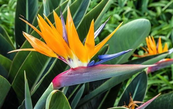
Boa Morte - Cabo Girau An old favourite is rejoined on its final leg today, the Levada do Norte. It’s always reassuring to begin a walk knowing you’re in the right place but make sure you turn towards Quinta Grande – the other way will lead you all the way to the North Coast. From its beginning at the source of the Ribeira do Seixal, this levada has braved cliff faces, tunnels, forests and hydro-electric schemes to settle down to a gentle meander around upper reaches of the urbanised coastal plain. Aloof from the noise of traffic yet affording fascinating glimpses into the lives of those who live below, this relaxed walk is full of interest and colour. In early December it takes just a few minutes with an ordinary camera to gather a kaleidoscope of colour that would arouse envy in many an English spring gardener.

Guided by the levada, the route slips between houses, along lanes and beside grassy banks, revealing back gardens and terraced plots.
Garden produce ripens on the roof tiles, detail in the terracotta roofing comes to life and family pets snooze in the hay. Weaving a trail around the valleys that are home to the villages of Boa Morte, Campanario and Quinta Grande, a slice of Madeiran life can be observed. Modern houses and sophisticated road tunnels are juxtaposed with postage stamp allotments and chicken coops. However these modest terraces, or “poios”, have supported viticulture on a commercial scale since the Age of Exploration in the 15th Century. Ships heading for the East Indies and the New World would stop for provisions and the Madeiran wine travelled worldwide. Early “Madeira” was inclined to spoil at sea and the addition of cane alcohol was made to aid its stabilisation. A unique character was added by the heat and movement of the casks on board which was discovered by the wine makers when one was returned unopened. The demand for these wines soared, referred to as “vinho da roda”, wine that had made the round trip. The 18th Century marked the peak of Madeira’s popularity; in Great Britain, Russia and North Africa from the Old World: in Brazil from the New World and, most enthusiastically, the American Colonies. Madeira was part of the consignment on board the sloop Liberty when it was seized by the British authorities in a dispute over taxes. The road to revolution is now well charted, but it was fitting that Madeira was used to toast the American Declaration of Independence. 
The trail continues around the valleys and the chimes of the church bells follow the walker, handing over from village to village with tones of different quality. Flowers burst from nooks and crannies yet, even in these tranquil surrounds, there are still reminders of this Island’s wild side. Eucalyptus trees fall and metal is twisted like spaghetti as a long past storm vents its anger. For us, dusk is falling as we thread our way through the upper terraces of Quinta Grande to reach the stunning Miradouro do Cabo Girao (thank you, Don Amaro) and we are a little too late to enjoy the wonderful views. You should leave earlier and enjoy this 550m vertical drop to the sea – perhaps take the cable car to the beach, maybe continue the walk to Camara de Lobos. Madeira – the place, the people and the odd new friend, will stick in my mind forever. What an adventure! Thank you, Macs Adventure.


 Australia
 New Zealand
 South Africa
 European Union