

A walking tour to Middle Franconia? The imagination conjures up a picture of toy shops and bakeries from a scene out of the ballet, Coppelia. On disembarking from the train in Rothenburg ob der Tauber, first impressions appear to be right. However this walk, along Germany's Romantic Road, is much more – it is an insider’s view on the Modern Middle Ages.
Rothenburg – Schillingsfürst
There is no excuse not to visit this region. Situated between Frankfurt and Munich, the early morning flight out of Heathrow leads to a mid afternoon arrival and time to wander. 
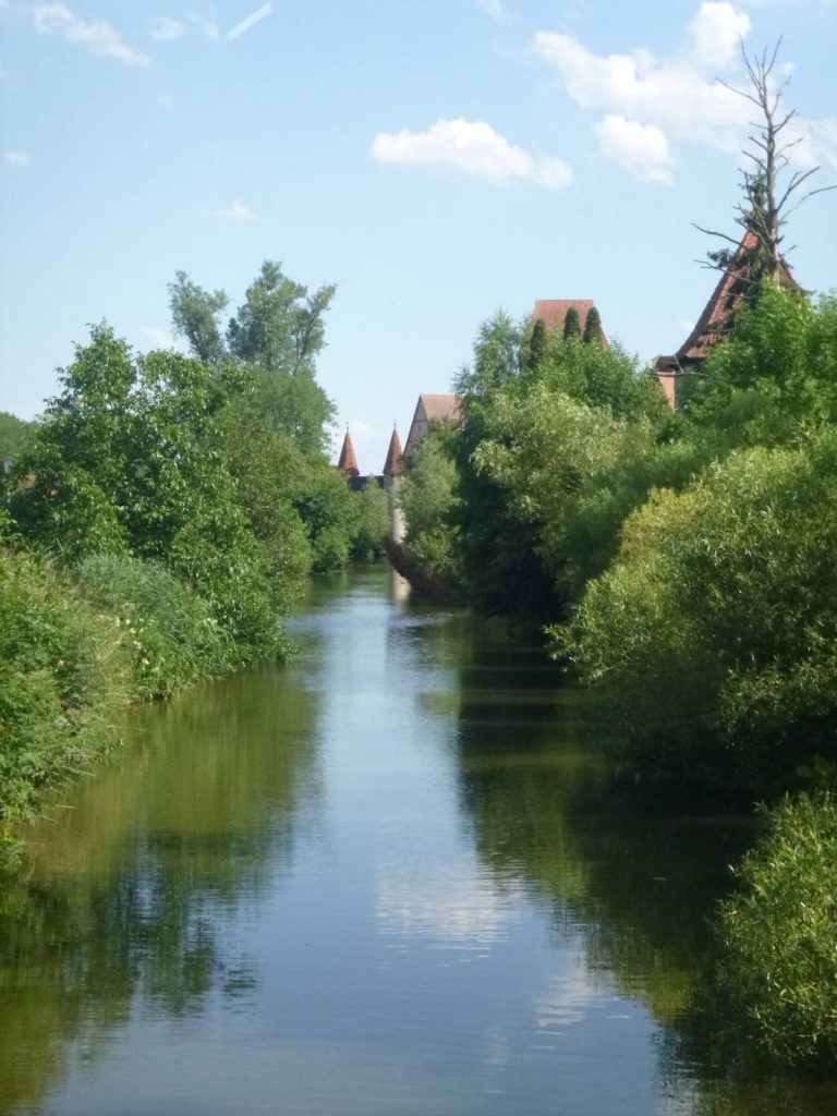
Gazing down on the tranquil streets of one of the most photographed towns of the region, it is easy to forget that this city of the Franconian Circle has witnessed more than its fair share of plague and war. 

At the traditional Hotel Gerberhaus, the servery groans under the sumptuous spread of the breakfast on offer. A nearby bakery provides fresh rolls for a picnic lunch and there is even time to chat with Dr Coppelius’s wooden protégé on the route out of the city. Founded in 1170, the town grew strong on trade until it was awarded the status of Imperial Free City by King Rudolf of Hapsburg in 1274. At the height of the Thirty Years War, in 1631, protestant Rothenburg was ransacked by the army of the Catholic League.
Three years later the Black Death struck, and the city’s development stagnated until the 1880’s when it was discovered as a tourist destination. Such was its reputation that the US Assistant Secretary of War, John McCloy, intervened when yet again destruction loomed in March 1945. Risking life and limb, six American soldiers carried a white flag to enemy lines. Defying his supreme leader’s orders, the local German commander gave up his position. Rothenburg was saved from further bombardment.
The summer festival of the “Meistertrunk” is a theatrical re-enactment of the events of 1631 when the invading general, the Count of Tilly, promised leniency if any of the council could down in one his welcome drink of a three litre tankard of wine. Taking up the challenge, the former mayor was clearly well acquainted with the “Frankenwein”, which today include Silvaner, Riesling, Pinot Blanc & Noir, and others, lesser known but equally good, and which often never leave the region. And Mayor Nusch’s challenge of the three litre tankard? It took ten minutes but he downed it in one.

As the walker leaves through the imposing masonry and complex defences of the Spital Bastion, the inscription over the main gate reflects the sombre lessons of the city’s turbulent history. “Peace to those who enter, farewell to those who leave.” Under a blue sky and through immaculately tended farmland, the route leads past neat villages and over gentle wooded slopes. 
This is the “Romantische Straße”, a route devised by the tourist industry in the 1950’s, which stretches some 350km from Würzburg to Füssen. Literally translated into English, the meaning is changed somewhat to suggest an amorous connection rather than the German word which conveys a description of a particular, slightly idealised, historical period. It matters little – the picturesque towns are well served with coffee shops and cosy restaurants, and the tranquil countryside displays colourful wild flowers that would suit either interpretation.

The day ends with a view over Schillingsfürst from the terrace of the Castle cafe. The castle itself is the main historical interest of the locality, for this town feels like a distinctly modern conurbation, serving the needs of those who work elsewhere. 
Nevertheless, the Flair Hotel Die Post welcomes walkers warmly with local fare and spacious rooms.
Schillingsfürst - Feuchtwangen

Today, departure is delayed by cannon fire. The dull booming draws the informed and the inquisitive to the Bavarian Falconry Centre and the visitor is greeted by a reconstruction of a military encampment of the Peasants’ Revolt of 1525. An exhibition of weaponry clearly displays its roots in the agriculture of the day and the crude implements send shivers down the spine. Sited on the ridge above the town, not far from the Castle, the Centre more commonly stages demonstration flights of highly trained hawks, the like of which were frequently used for hunting in the Middle Ages.

The route leads on through the manicured landscape. The surface is hard and even, either tarmac lane or gravel forest road, and scarcely a clot of mud is encountered through the farmyards. Subtly the ancient farmlands reveal another face to the passing observer. Giant wind turbines turn silently, solar panels gleam in the heat of the day and biomass electricity generators are tucked unobtrusively in the corners of fields. Yet there seem to be no massed ranks of appliances marring the landscape.

Walking through the Franconian Heights, the trees of a varied woodland tower over the path. Frequently, the walker emerges from the cool forest into the sunlight of an open glade where an explosion of low shrubs lines the way. In mid July, it is easy picking to gather sweet wild raspberries. Blackberries too but, later to ripen, they are still tart. Deer can be spotted and kites wheel around shallow valleys. In this terrain, the occasional motorway disappears – just climb the next low ridge and it’s gone.

Within a world of forested hillside and golden wheat field, small hamlets are dotted throughout – all are spotlessly clean, all seem recently refurbished. They form a rural idyll that is almost too perfect, but the underlying modernity and ancient heritage enjoy a relaxed symbiosis that surely is a very good environment in which to live. Feutchwangen provides accommodation and sustenance for tonight in a blend of the previous two stops. Here modern, slightly utilitarian suburbs are contrasted starkly by a classic medieval old town.

Music resounds across the cobblestones as sections of an orchestra warm up for the evening’s performance of the Cloister Plays. To the left of Stiftskirche, the 12th Century former Romanesque monastery church, are found the Kreuzugang, the Cloisters, which house the annual music and drama festival. The Altstadtfest, Moosewiese and Weihnachtsmarkt are all traditional celebrations held throughout year in the Old Town. Compare such antiquity to the space-age edifice of glass and concrete that stands just outside the town, Casino Feuchtwangen – one of the highest earning gambling houses in Bavaria.
Feuchtwangen – Dinkelsbühl

Behind the Röhrenbrunnen, an 18th Century baroque fountain, the Red House cafe tempts the walker with pastries and coffee before commencing the day’s hike. And why not? This leg is the shortest of the tour, it would be a shame to rush a leisurely day to find your accommodation unprepared for your checkin. On the outskirts of the southern suburbs, the path crosses a footbridge over the River Sulzach near the hotel and restaurant, “Gasthof Walkmühl”, built on the site of the former watermill. Although not obvious to the hiker, there has been a fundamental change to the natural water course, the European Watershed has been crossed. Whereas the River Tauber runs North West, the Sulzach flows South East. Water from just North of Schillingsfürst flows via the Main and Rhine to the North Sea. From the South side of the same town, the flow is to the Wörnitz and Danube – the bubbling brook that you have just crossed is destined to become a drop in the Black Sea.

The track leads into the Frickinger Wald, a region of pine and deciduous forest occupying a low ridge between the Sulzach and the Wörnitz rivers. Further evidence of Germany’s energy programme is encountered. Giants of ferro-concrete and fibre-glass whirl majestically, the whine of machinery so muted that it is obscured by the crunch of boot on gravel. Yet this enterprise is not some nefarious dream. The latest statistics demonstrate that some 31% of the country’s electrical power was generated from renewable sources. And not only is it power that is generated – Siemens, Europe’s largest engineering company, attributes €27 billion annual revenue to renewables. Nevertheless, it is disconcerting for the walker to stumble on such prominent landmarks in the forest and discover that, like electrical pylons on French IGN charts, they do not appear on the map.
The first sign of the journey’s end are the watch towers for which this city is renown. A walk around its walls reveals sixteen before the count becomes confused amongst the lesser turrets and spires. Once a Mixed Imperial Free City, governed by a joint Catholic/Protestant council, Dinkelsbühl, like Rothenburg, has its own tale of salvation by heroic intervention. Every summer, the “Kinderzeche” celebrates the city’s surrender to the Swedish Army and the teen-aged girl who led children to the Swedish general to plead for mercy. Touched, the general restrained his troops and the population was saved from massacre.


Dinkelsbühl – Raustetton
Breakfast for two at the excellent Hotel Piazza sets up the walker for the longest leg of the tour. Fourteen miles of tarmac lane and gravel forest tracks that cut through the western edge of the Oettinger Forest and across the Wörnitz Valley.

Wild poppies thrive amidst the lush greenery at the outflow of the carp ponds. Fresh fish is frequently served in Franconian restaurants; carp, usually fried in batter, rainbow trout, zander. For a real treat try the sweet, white flesh of the latter with Hollandaise sauce.

Forest tracks stretch away ahead; conifer, deciduous, often mixed. Expect to walk for long periods without meeting a soul, and although sustenance can be found en route, opening times are rarely convenient and diversions off the path may be required to find shops or cafes. Picnics are recommended for every stage of this tour, and quiet spots with a view are plentiful. The signage for the Romantische Straße is an overlay upon a more ancient route – the Main-Donau-Weg. From the days of the Holy Roman Empire, there have been dreams of a North Sea to Black Sea waterway, yet not until 1992, with the completion of the Main-Donau-Kanal, was it fully realised. The overland trade route of the Middle Ages loosely followed a similar line, but it was fractured, split into multiple threads. Today four different signs mark the route –

– choosing the wrong one could add miles to your journey. Green is for the cyclist, brown for the motorist, blue/black for the hiker – however it is the blue on white, painted, peeled, faded or brand new, of the Main-Donau-Weg that faithfully leads the walker all the way. Raustetton is a haven of serenity. A small church, two guest houses, a few cottages and a farm: there is no public transport, no mobile signal and very little noise.

Gasthof Waldeck looks after the walker well. Grudgingly a euro or two is paid for an hour’s internet connection but it is a relief when the time expires and the outside world retreats once more.
Raustetton – Nördlingen
The last day of the tour sets out on a now familiar path of metalled surface and gravel track, and the walker should consider what footware to use for this hike. A sturdy walking shoe, not necessarily Gortex lined but with good cushioning, is more than adequate. After five days of constant movement, you feet will thank you for comfort rather than the weight and support of a full boot. The tiny church on a round-about in the village of Enslingen and the more imposing Kloster Maihingen are typical of the style and quality of the public buildings. However another significant, geophysical change is about to take place.


This is the Nördlinger Ries, a difficult formation to visualise from a ground level photograph. Beyond the green grass, there are two low ridges separated by approximately fifteen miles; the first has fields quilted with green and gold crops, the second is a distant grey line between the earth and the sky. In between, its extremities spread too far apart for the camera lens, lies a 14 million year old meteor crater.


Until 1960, the Ries was thought to be of volcanic origin however two American scientists proved the extraterrestrial theory using the presence of “shocked quartz” in the stone used in the construction of Nördlingen church. Above the exposed crater floor, grey clouds thicken and rain sleets across the flat terrain. Intensive agriculture dominates and drainage channels, not seen outside the Ries, criss-cross the fertile farmland. It is sobering to learn that, although the central plain is less than five hundred feet below the crater wall, the initial crater depth would have been tens of thousands of feet deeper. Within minutes of the impact of the mile wide meteor, a complex self-levelling process would have taken place and then been followed by eons of settlement and erosion.

Threading through the wet streets of the northern suburbs, “Daniel”, the 300ft spire of St George’s Church and Nördlingen’s premier landmark, guides the walker to the very centre of the city. The stone of the church’s construction, like other city buildings of its period, contains millions of tiny “impact diamonds”, in all an estimated 72,000 tons of them, created during the prodigious explosion of energy from the planetary collision. Rain drops glisten on the cobbles, medieval masonry becomes black with moisture and there is no sign of a diamond sparkle. However such disappointment is short lived on climbing the ancient, uneven staircase of the Kaishof Hotel Sonne, where awaits plush accommodation and great Franconian food. Great trip, thank you, MacsAdventure, John walked Germany's Romantic Road, exploring the fascinating "cities of the Holy Roman Empire".


 Australia
 New Zealand
 South Africa
 European Union